The origin of the Ordnance Survey lies in the appointment of a Trigonometrical Survey in 1791, to provide a complete cartographical survey of the country for military purposes.
The project to produce the County Series of Ordnance Survey maps for Great Britain was begun in 1840: this was the first ever comprehensive mapping of England, Scotland and Wales.
The County series for the Swindlehurst region of Lancashire and Yorkshire were published during the period 1840-1850 at a scale of 1:10560 (6 inches to the mile.) The sheets cover an area 6.17 miles E-W by 4.10 miles N-S on a sheet 37.03" x 24.61".
Note that the Lancashire and Yorkshire County maps do NOT line up cleanly at the border, the Yorkshire maps are shifted 1.05 miles (6.27") south and 3.29 miles (19.75") west relative to the Lancashire maps. This does make it a little tedious to study regions that span the county border.
Also remember that county boundaries have been re-defined a few times since 1850 by politicians anxious for a few extra votes.
It is my understanding that these maps remain perpetually Crown Copyright within the UK, but world-wide copyright expires after 50 years, so that within the USA where these maps are stored, they are in the public domain.
These maps are made available for use in investigations of the family histories of the Catteralls and Swindlehursts of north east Lancashire and the borders of the (old) West Riding of Yorkshire.
These links are to the small area around the Swindlehurst region.
1850 Ordnance Survey 1:10560 first County Series maps of Lancashire
1850 Ordnance Survey 1:10560 first County Series maps of Yorkshire
A new, expanded index of Lancahire maps has been added (October 2009) covering the Catterall area and more of Lancashire.
Present status: North and south Lancashire the maps in the index work, also the navigation links in these sheets. But there are no local names in the index. These will be added as and when I have time. Coverage of south Lancashire, especially the manchester area is somewhat spotty - this will not be rectified as I do not have those sheets.
1850 Ordnance Survey 1:10560 first Lancashire County Series
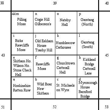
In the expanded index the maps are organised in groups of 16 sheets, numbered sequentially east-to-west and then north-to-south, from 24 down to 65. Within each group of 16 sheets the individual sheets are are labelled by the letters a to p, 4 to a west-to-east row and increasing to the north.
Each sheet in the index map is labelled with at least one name of a principal feature, such as a town, hill, or bridge etc. As far as possible these names also occur on current Ordnance Survey 1:50,000 or 1:25,000 sheets, and the index is best used together with one of these modern sheets. On a few sheets there is no prominent feature, and the label is simply one such as 'moors'.
Thus, for example:
Clicking on a sheet in the index will bring up the corresponding sheet. On each sheet page there are direct links to the 8 adjacent sheets (north, south-east etc.) at the top and bottom, left hand end of each sheet. There are also links to the extended Lancashire index page and to the Yorkshire index page.